Pinecrest Lake Cycling
Bike Trails, Bicycle Rentals, Scenic Routes
Bicycling on Sonora Pass roads and bike paths doesn't get much better than the area around Pinecrest Lake. In the summer bicycle rentals are available at Pinecrest Lake at The Pinecrest Hub next to the little shopping center. The Hub rents several varieties of bicycles, including children's bikes. For $1 you can purchase a map of the area with bicycling routes for both road and mountain biking.
For casual bicycling, the little community of Pinecrest makes a good place to explore. Light traffic and few hills make for easy going. Also winding through the campgrounds can sometimes be fun. A paved walking/bicycle trail runs from Pinecrest Lake past Pinecrest Campground and out through Meadowview Campground.
Shop Amazon: Cycling Essentials
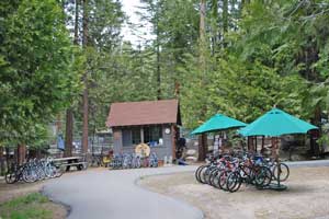
The Hub - Bicycle Rentals
For experienced cyclists, consider the road up to Dodge Ridge. It sees only moderate traffic in the summer, but should still be approached with caution. The 3½-mile road climbs 1000 feet, making for a strenuous ascent. Several sharp curves deserve particular caution. (not suitable for children)
Cycling in Twain Harte
Twain Harte has good bicycling roads for the casual rider. There are enough hills to give you a solid workout if you choose, and it is always interesting to ride around vacation communities looking at the various cabins and other sights.
For experienced cyclists the 7-mile ride down to the town of Tuolumne passes through scenic countryside. The road drops about 1200 feet, making for a long climb back to town. Another route with plenty of hill work is the South Fork Road, 5 miles from Twain Harte to the Stanislaus River. The road climbs 500 feet out of Twain Harte and then drops 500 feet to the river. It is narrow and deserves considerable caution.
Bicycling on Sonora Pass
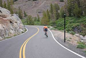
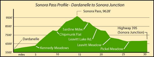
For serious road cyclers the trip over Sonora Pass can be a challenge. In places the grade reaches about almost 20% with an average of 7%. Riders generally start out in the Dardanelles area early in the morning and push off for the pass with a supply of water and nourishment. The first five miles are generally level, giving your body a chance to warm to the task ahead of you.
Then in the next one mile the road climbs 1,000 feet in elevation. To the top of Sonora Pass from Dardanelles is 14½ miles, with an exhausting 3,500' total gain in elevation. The road is narrow and with many blind turns, making safety an important consideration.
Some cyclers continue on over the east side of Sonora Pass, dropping 3,000' in 11 miles to Pickel Meadow and then turning around and going back the way they came. Others keep on going all the way out to Highway 395 at Sonora Junction, making it just over 30 miles from Dardanelle.
For more about this cycling route, see Pjamm Cycling - Sonora Pass.
The Complete Guide to Climbing (By Bike) in California (2014) covers the rides up both sides of Sonora Pass and other great summits in the area.
Cycling along the Clark Fork Road
The 11-mile Clark Fork Road is an enjoyable route with a mild grade, climbing only about 1,000' spread fairly evening along its length. Park near the bridge soon after turning onto the Clark Fork Road from Highway 108. Then ride up to the end of the road at Iceberg Meadow where you could rest and have a picnic before coasting back to your car.
Herring Creek Road Bicycle Routes
The 4 paved miles of the Herring Creek Road climbs about 1,000'. Traffic is generally light on the road and it passes through shaded forest at about the 6,000' elevation. You will find Herring Creek Road - the starting point of this ride - about 2½ miles east of Strawberry on Highway 108.
Cycling the Old Strawberry Road
The narrow, shaded Old Strawberry Road makes a nice bicycle ride. Start in Strawberry or at the upper end where the road joins Highway 108 a mile east of Cold Springs by the Pinecrest School. The 3-mile long road drops about 400' from Pinecrest School down to the Stanislaus River at Strawberry and then climbs a short grade to rejoin Highway 108.
Bicycle from Pickel Meadow to Sonora Junction
This easy 5-mile begins at a little turnout on Highway 108 at the west end of Pickel Meadow on the east side of Sonora Pass. From there you ride east on Highway 108, passing the Marine Mountain Warfare Training center. Off to your right will be the expanse of Pickel Meadow and the easy flowing West Walker River. In the distance you can see snow-clad Tower Peak. The route drops down to a bridge across the river and then begins a gentle climb to Sonora Junction. Highway 108 ends there as it meets Highway 395. You could continue your ride on 395, but it has a lot more traffic.