Sonora Pass Vacations
HOME
Lodging and Camping
Recreation Areas
- Clark Fork
- Dardanelle
- Dodge Ridge
- Kennedy Meadows
- Leavitt Meadow
- Leland Snowplay
- Mi-Wuk Village
- Pinecrest Lake
- Strawberry
- Twain Harte
- Wilderness Areas
Current Conditions
Outdoor Recreation
- Backpacking
- Bicycling
- Boating
- Day Hiking
- Fishing
- Golf
- Horseback Riding
- Miniature Golf
- Mountain Biking
- OHV
- Picnicking
- Swimming
Sightseeing:
Events
Services
- Emergency Services
- Church Services
- Forest Service
- Pack Stations/Riding Stables
- Restaurants
- Stores and Gas
Winter Activities
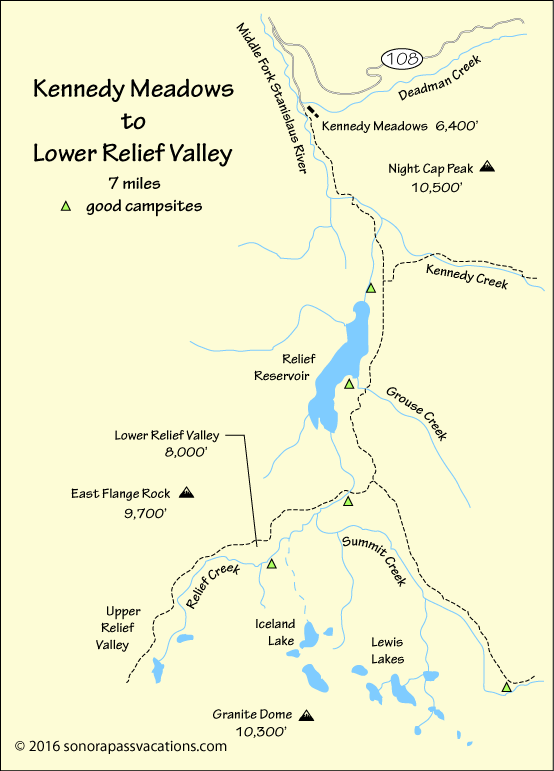
The Trail to Lower Relief Valley
To the Site of the Historic Relief Camp
Lower Relief Valley, spread at the foot of jagged East Flange Rock, is the site of the Relief Camp where a rescue party from Sonora met a party of destitute emigrants and guided them down the mountains to Columbia. Lower Relief Valley is a picturesque mountain meadow with plenty of good backpacking camp sites and rewarding fishing in Relief Creek.
The 7-mile hike to Lower Relief Valley leads up from Kennedy Meadows past Relief Reservoir and then up Relief Creek to the valley. This backpacking trip is best done after the high spring runoff since the Relief Creek crossing above the reservoir can be tricky when the water is rushing. For adventurous cross-country hikers and peak climbers, several great destinations are within reach of a Lower Relief Valley camp.
Hiking Guide to Lower Relief Valley
Getting Organized
Wilderness Permits for the backpacking trip to Lower Relief Valley can be picked up at the Summit Ranger Station near Pinecrest or the Bridgeport Ranger Station in Bridgeport. Park at the trailhead parking lot a quarter mile before you reach Kennedy Meadows. Pick up last minute supplies at the Kennedy Meadows Resort store.
Starting the Hike to Lower Relief Valley
Hoist up your backpack and set out on the dirt road beyond the pack station. The road soon evolves into the trail, leading up the canyon on the old dam construction road. After an hour of hiking you will pass the site of the PG&E maintenance cabin (dismantled in July 2011) a mile before Relief Reservoir. Continue hiking up the trail and along the side of the valley above the reservoir.
The Heart of the Hike
If you want to split your approach hike into two days, try camping at Relief Reservoir just beyond Grouse Creek. A "use trail" will lead you down to excellent backpacking campsites on a point of land overlook the water. Otherwise, continue up the trail to a junction. Turn right there, climb a slight ridge and descend to Relief Creek. Good campsites can be found there. Cross the creek and follow the trail upstream to Lower Relief Valley.
Camping at Lower Relief Valley
Hike up to the main expanse of the valley and head across to the south side of meadow, finding good camping along the creek. Some of the better campsites are tucked up among the trees on the south side of Relief Creek. There are also good campsites at the head of the valley.
Nearby Adventures
- Hike to Iceland Lake - Only for experienced cross-country hikers and do not attempt alone. Route finding up from the valley to the lake may involve some Class 3 scrambling. A safer way to approach Iceland Lake is to circle around through Upper Relief Valley. Use caution. In 2008 a lone hiker died near Iceland Lake when he fell into a granite crevasse.
- Hike to Lewis Lakes - Return on the trail to the Summit Creek trail, follow it up until adjacent to the Lewis Lakes drainage, cross the creek, and follow the drainage up to Lewis Lakes. Summit Creek crossing is dangerous early in the summer.
- Climb Granite Dome - For experienced cross-country hikers and peak climbers. Hike up to Upper Relief Valley and then head southeast toward Granite Dome. The western ridge offers a fairly easy ascent. 10,300'. Class 2.